This Way Application
DESIGNED BY:
Açelya İster, Berkay Karanfil, Hakan Özcan, Muharrem Tonyalı, Simay Gedik, Eylem Yurtsever (SDFB)
INTRODUCTION:
The project aims to widen the scope of safe transit applications on motor highways and build a more accessible transportation system for persons with visual disabilities. The project aims at increasing accessibility in transportation not only for persons with visual disabilities but also for pedestrians with disadvantages in their ability to move and who are not defined within the disability group. The project initially focused on the problems faced by persons with visual disabilities in urban transportation and the use of awkward public spaces; however, the discussions have led the direction to build a mobile application covering the needs of all disadvantaged groups.
As a result of preliminary research, the NGO presentations and the meetings held with the NGO design partner, numerous challenges and problems faced by persons with visual disabilities during transportation in daily life were identified, and possible solutions were proposed based on these problems. These are the targeted problems to be solved with this project:
- The problem about the volume of signals at pedestrian crossings, which is insufficient depending on the traffic density, but at the same time, it is uncomfortable high when the traffic density is low,
- Occupation of the yellow warning strips on the ground at pedestrian crossings,
- Lack of warning signs for people with disabilities at every pedestrian crossing,
- The difficulty of individuals with disabilities to have access to a support vehicle in case of an emergency,
- The challenges faced by individuals with or without disabilities because of possible irregularities on pedestrian sidewalks and due to the disturbance caused by maintenance work,
- The challenges faced by individuals who could be situationally defined as disabled (e.g. people with strollers), particularly in places with dense pedestrian traffic,
- Lack of proper guidance of users with the existing mobile applications on wayfinding.
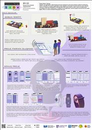
The application designed within the scope of the project is proposed to operate in conjunction with the existing navigation applications. It is envisaged that the current navigation applications with the built system will be applied to pedestrian traffic in line with the operating principle used for vehicles. Thus, it is aimed at creating an application that would be used not only by persons with visual disabilities but by all pedestrians using this system. The pedestrian density along the designated route will be identified and the user will be forwarded to less dense areas. At the same time, people with disabilities will be directed to the safest pedestrian crossing, and the risks for individuals with all kinds of disadvantages will be minimised. In support of this navigation application, a smart wristband was designed to prevent problems faced by persons with visual disabilities when using pedestrian crossings. This wristband was designed to help users know about the position of traffic lights and guide them.
Considering the possibility that GPS based data cannot detect the exact point while determining the location of traffic lights and the possibility of deviations in the position of the lights, the project also aims to add a sonar system to traffic lights to minimize such deviations and to enable access to the exact location of the traffic light with the help of the waves emitted from the smart wristband. The smart wristband will only have an on and off button and a panic button, and it will have a simple and functional design. There are two colour options for the smart wristband; the keypad can be customised, and the position of keys is also variant in different colour options.
The use of application starts with registration. The application allows login with application accounts like Google Maps, Yandex Maps, etc. First-time users are required to enter information like their system username, email address, password and indicate their particular condition if they have any (type of disability, etc). The main reason for adding this section is based on the content of the application's ability to develop an option for each group of users' needs. After the registration, the user is forwarded to the main screen where they are given three options on permitting using location information: i.e., 'always allow', 'allow while using the app' and 'never'.
Once the location information is shared, the user is forwarded to the main screen with an upper menu bar including buttons for “emergency needs”, “saved” and “search” and a menu bar at the bottom with buttons for “pedestrian view”, “vehicle view” and buttons for the smart wrist band. When clicked, the button for emergency needs directs the reader to the page with options related to daily needs like market /shopping mall, hospital/health centre, pharmacy, ATMs and police stations. According to the selected location options, the application automatically generates a list of alternative routes for the closest places like market, hospital, etc., and a list showing distances. The application offers the user the closest routes depending on the selections made from the list. In addition to the closest distance calculation, the ThisWay application also offers the user the most convenient and safest route based on their route preferences. The purpose of the application is to calculate the closest route and list the safest and less dense options for comfortable physical transportation and provides alternative routes in this respect.
One of the differentiating features of the ThisWay app is the wider capability of the routing functionality. The app not only shows users the registered places but also assists users in creating registered places and enables keeping a record of the accessible routes used frequently by individuals with disabilities as well. The 'search' button on the upper panel, like map applications, allows user to search their destinations and follow their frequent and existing searches. The menu bar also includes tabs for “profile”, “discover”, “weather condition settings” and “help”. On the settings menu, there are options are for activating or deactivating the smart assistant on start. This application feature makes it easy for the user to connect to the assistant after opening the application without any additional step. The settings menu also has a tab for enabling the 'colour-blind' mode for making the app easier to use for the colour-blind individuals.
The main screen of the app shows the current location, and it is possible to change settings for pedestrian or vehicle mode depending on the type of transportation. If the app is running on pedestrian mode, it can inform the user about traffic density on both sidewalks on wide streets, and it offers an average density data on narrow streets. The app also keeps data in dense areas updated with instant notification capability for users who created an online data point.
Please visit the link to review the interface of the application: https://xd.adobe.com/view/cb34db1b-75b2-493d-57cb-bfce512f2485-bd05/grid